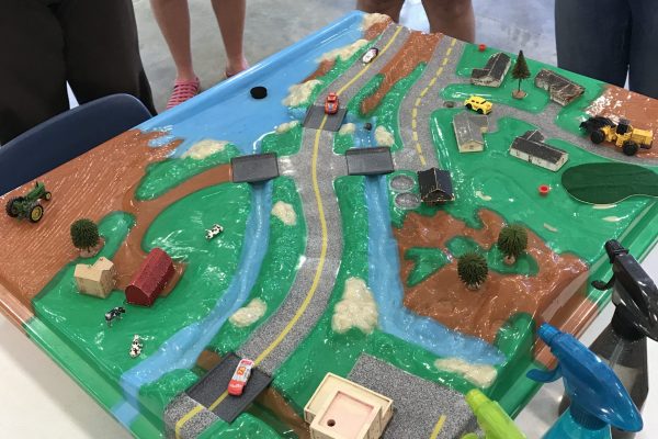

An EnviroScape model is a 3-D self-contained mini watershed. It allows students to observe and simulate, in real-time, the interactions of precipitation with various land-use practices and the impacts they have on streams, lakes, water supplies, and groundwater. An EnviroScape model allows you to simulate many sources of both point and nonpoint source pollution, create floods, pave over a field here, plant a buffer there and see what happens.
EnviroScape models have been provided to several hosts throughout the state of Alabama, by Legacy, Partners in Environmental Education. All EnviroScape models may be checked out by teachers, schools, or other educational organizations by contacting the host in your area.

We all live in a watershed with water pollution from many sources. Nonpoint sources contribute a great deal to the pollution in our water bodies. The combined effect of pollution from many small sources can have a real impact on the quality of our shared water resources.
EnviroScape® Watershed/Nonpoint Source tracks pollution from point and nonpoint sources, including
Nonpoint Sources
Point Sources
The Watershed/Nonpoint Source unit includes: Nonpoint source landscape top (topographical map) with the storm drain pipe, clear base, houses, barn, factory, drain pipe, treatment plant, trees, golf flags, cows, cars, and best management practices such as buffer strips, clay berms, manure container, soil, oils and chemicals (cocoa, drink mixes and oil mix), bridges, water catcher, rainmaker, water plug, and User’s Guide.
Stormwater pollution and runoff are visually apparent when rain falling over the landscape top carry soil (cocoa), chemicals (colored drink mixes), and oil (cocoa and water mixture) through a watershed to a body of water. Stormwater runoff and storm drain function are also addressed.
Best management practices include felt buffer strips as vegetation, clay to create berms, and other methods to show conservation and water pollution prevention measures at work. The model shows nonpoint source pollution and the steps everyone can take to help prevent environmental contamination.
EnviroScape Watershed/Nonpoint Source also teaches an overall watershed concept. Two waterways flow into a larger water body, which is representative of a lake, river, bay, or ocean. The unit comes complete with a kit containing everything you need to demonstrate the movement of water through a watershed and the pollution that runoff may cause.
Jacksonville, Alabama
JSU Field Schools – Jacksonville State University
Contact Person: Rebekah Taylor
rmtaylor@jsu.edu
700 Pelham Road North, Suite 246 Martin,
Jacksonville, AL 36265
(256) 845-3548
Auburn, Alabama
Auburn University
Alabama Water Watch
Contact Person: Carolina Ruiz
awwprog@auburn.edu
961 S. Donahue Drive
Auburn University, AL 36849
(334)-844-4785
Birmingham, Alabama
Cahaba River Society
Contact Person: La’Tanya Scott
latanyas@cahabariversociety.org
2713 7th Avenue S, Suite 205
Birmingham, AL 35233
(205) 322-5326
Dothan, Alabama
Landmark Park
Contact Person: Jenni Clark
jenni@landmarkparkdothan.com
430 Landmark Drive
Dothan, AL 36303
(334) 794-3452
Huntsville, Alabama
Contact Person: Alma Huston
alsie5472@gmail.com
2800 Day Circle
Huntsville, AL 35801
Gulf Shores, Alabama
Learning Center at Gulf State Park
Contact Person: Kate Colman
kcoleman@learningcampusgsp.com
20249A State Park Road
Gulf Shores, AL 36542
Montgomery, Alabama
Legacy, Partners in Environmental Education
Contact Person: Toni Bruner
toni@legacyenved.org
P. O. Box 3813 (mailing)
Montgomery, AL 36109
***Legacy also hosts the Wetlands, and the Landfill EnviroScape Models.
Physical/Shipping Address:
1333 Carmichael Way
Montgomery, Alabama 36106
Mailing Address:
P.O. Box 3813
Montgomery, Alabama 36109
1-800-240-5115 (toll-free)
334-270-5921
334-270-5527 (fax)
Sign up & stay up-to-date with Legacy